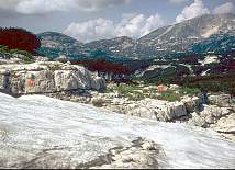
Entrance 91 looking north towards 93 and Schönberg
| 91 | Bräu schacht 91 | 1/S + |
|---|
Altitude: 1645m, Depth 20m.
Position: E N
GPS: UTM 33T 0410171 5280908; UTM 33T 0410155 5280976; UTM 33T 0410177 5280894
Bearings:
Schönberg 347°, HSK 054°, VSK (nipple) 108°,
Bräuning Nase 150°, Bräuning Wall pt. 1828 210°,
Bräuning Wall pt. 1835 224°
Marking: number in red (1977) on small scarp facing south,
1998 tag "1623 91 CUCC 1977"
Location: Plateau - below Bräuning Scharte.
Approach: From Schwarzmoossattel, follow cairned path below the Bräuning Wall, past Top Camp (1988 on). Where this path meets the scree/snow slope from the wall, it turns right, out onto the plateau (this is the main path to Gschwandt-Alm, in frequent use).
100m from the right turn is a snow field on the right, with the sound of falling water at its lower edge. This is the entrance to 91. The bolt is at the NE end of the rift.
A snow-fed rift in open karren on a fault/joint aligned on 67°. Choked at -20m (or plumb of -14m in 1996 to tiny snow plug).
Exploration: CUCC 1977 - Team Enthusiast.