| 154 | Schwa Schacht 154 | 1/S x |
|---|
Altitude: marked entrance 27.3m higher than
153, ie. 1771.m; lower entrance is 8.2m below marked
entrance, ie. 1763m
Position: E 36105, N (52)81974
Location: ~60m on 222° from outcrop which is ~100m on 10° from 153.
From 153, follow gully, keeping slightly left to end (10° magnetic), climb over ridge to left and continue with next gully into depression. Lower entrance in bottom of depression, but this is not marked, on over next ridge to find marked entrance.
Loose pitch head gives onto 5m entrance pitch. A rift leads off but quickly chokes, while a draughting slot could be dug, but is rather loose and dangerous, so was left.
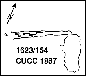
This doesn't sound much like the 1985 log book description, which is of a climb down in a rift below the survey mark into a chamber with daylight entering in two or three places. There is another way out, though where this is isn't mentioned, and the cave needed a rope to push further. However, the 1987 sketch does sound like this ! It is not clear whether the 1987 push addressed the way out needing a rope - perhaps another look would be a good idea, if a party is working in this area.
Survey: Grade 1 plan (no scale) from 1987 Log Book, surface survey from Bunter's Bulge.

Exploration: Discovered CUCC 1985 (on last day), explored 1987