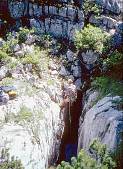
Adam Cooper descending to place a bolt below the lip in 1993
| 200 | Verlorener Rucksack Schacht | 1/S + |
|---|---|---|
| = CUCC 1993 01 | Lost Rucksack Cave |
Altitude: 1647m, depth 45m
Location: E 35479, N (52)83052
700m north of Schwarzmoossattel.
Marking:M6 stud with alloy tag "CUCC 1993 01" on flat rock NE of shaft. This will be replaced with the correct kataster number in due course.
Access Route: From 164, avoid 189 (easiest 15m to its right over a small ridge, but OK immediately on its right edge), then go roughly NNW (a few cairns - 1996 vintage orange paint has completely faded). This leads up onto the right edge of a ridge (the main part of which is deep Lätchen), passing right of the OAV ski marker pole. This is an easy walk above a short (climbable) cliff looking down onto CUCC 1998-03. When this easy walk is interrupted by a step down, head leftish over a series of limestone steps to reach a descent into a large broken area (near 173). Climb steeply left up boulders to a large cairn, then along a sloping limestone shelf. Shortly ahead is an abrupt headwall, below which is the shaft of Lost Rucksack Cave (given temporary number CUCC 1993 01). The area could also be reached (with more difficulty) from the "central" plateau area towards 76, and also via the "Geologists' walk" which passes much further left via 171 and 172.

Found in 1993, it was intended to mark the cave but not descend. However Adam Cooper's rucksack (containing the rope), placed unwisely near the edge, made the first descent. Adam followed on a ladder to retrieve it, then placed a bolt for a further descent on rope. The shaft continued beside a snow plug, but was deemed unsuitable for further exploration in shorts. The find was not relocated in 1993, so exploration stopped. Found again in 1995 whilst marking other known entrances, and probably seen again in 1996.
After a first descent placing a bolt again showed it unsuitable for exploration in shorts, a determined effort by Wookey in 1998 pushed the second pitch, between hanging death ice and snow to a definite choke. However, partway down this pitch was a window with a draught, leading to a third pitch (one bolt at takeoff, another just below). This was nn metres to a final choke.
The whole cave is formed on a fault which forms a SE-facing scarp on the surface. A short distance NE of the entrance, the fault line cuts a lower-lying area. The draught, which was mostly outward through the head of the third pitch during the final exploratory trip, periodically reverses for 10-15 seconds. It would appear to be powered by surface breezes via various other small windows to the surface, most probably including ones lower down in the depression to the NE.

Exploration: Discovery and initial descent CUCC 1993 (Adam Cooper), bottomed in three trips in 1998 (Wookey, Andy Waddington).